Punxsutawney Phil, the world's most famous groundhog, saw his shadow early Sunday morning, signaling six more weeks of winter. But beyond Phil, private weather forecasters warn that another round of extreme cold could pour into parts of the Lower 48 by the middle of February.
"Holding off for now, but we may need to declare a climate emergency for extreme cold and snow during the middle of February," meteorologist Ryan Maue wrote on X. He said, "The Polar Vortex could penetrate deep into the Lower 48 like early last month."
Holding off for now, but we may need to declare a climate emergency for extreme cold and snow during the middle of February.
— Ryan Maue (@RyanMaue) February 2, 2025
The Polar Vortex could penetrate deep into the Lower 48 like early last month. pic.twitter.com/Wh9v3cttsM
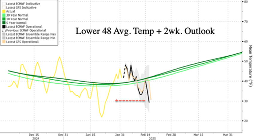
By mid-Feburary, weather models show that average temperatures across the Lower 48 are set to slide well below the 30-, 10-, and 5-year averages, reaching lows similar to last month's cold blast—one of the coldest January in years for some areas of the US (read here).
Private weather forecast BAMWX also confirmed the forecast: "The upcoming pattern lines up rather nicely with years like 93,14 and 2021. The BIG wildcard could be the -NAO that might rival years like 2010 etc. There really isn't a great match overall for the upcoming -EPO/-PNA/-NAO/-AO mid Feb pattern."
The all model NAO forecast is remarkable. There will without a doubt be some big eastern US snow risks. pic.twitter.com/VW3dYkNwsc
— BAM Weather (@bamwxcom) February 2, 2025
"The potential for a significant deformation of the Polar Vortex and its split through mid-February is increasing," Severe-Weather EU wrote on X.
Are you ready? The potential for a significant deformation of the Polar Vortex and its split through mid-February is increasing.
— severe-weather.EU (@severeweatherEU) February 2, 2025
Stay tuned for an in-depth analysis and forecast soon. pic.twitter.com/HMgHSKFir4
Potential snow risks ahead for Ohio Valley, Central Appalachians, Mid-Atlantic, and Northeast regions.
The latest ensembles show 2 upcoming snowstorm windows in the eastern & central US - the last few runs generally targeted the following highlighted corridors, though as always, forecasts this far out can & will change.
— Tomer Burg (@burgwx) February 2, 2025
So what's driving each potential & what's the uncertainty? pic.twitter.com/GARntJlihH
The coldest temperatures of the winter season occurred in mid-January. Temperatures are expected to trend higher later this month.
Global warming alarmists have been awfully quiet this winter as cold weather records were shattered in many parts of the country, including a blizzard in New Orleans.

