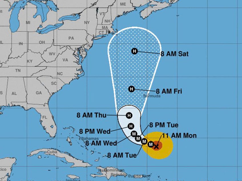
The southeast United States is escaping the wrath of Hurricane Lee with a coming sharp turn north, but its final path remains uncertain as those in the northeast eye the storm, anticipating possible impact.
As of Monday morning, National Oceanic and Atmospheric Administration (NOAA) hurricane hunters found that the storm remains a “major” hurricane as it makes its way across the Atlantic Ocean.
Hurricane #Lee Advisory 25: Noaa Hurricane Hunters Indicate That Lee Remains a Major Hurricane. Hazardous Surf and Rip Current Conditions Expected At Beaches Across the Western Atlantic All Week. https://t.co/tW4KeGdBFb
— National Hurricane Center (@NHC_Atlantic) September 11, 2023
“Dangerous surf and life-threatening rip currents will affect portions of the Leeward Islands, the Virgin Islands, Puerto Rico, Hispaniola, the Turks and Caicos Islands, the Bahamas, Bermuda, and most of the U.S. East Coast through much of the week,” the National Hurricane Center’s 11 a.m. update read, warning that the storm could bring “strong winds, rainfall, and high surf impacts to Bermuda” later in the week.
Still, the NHC said it is still “too soon to know what level of additional impacts Lee might have along the Northeast U.S. coast and Atlantic Canada late this week and this weekend,” but it warned of wind and rainfall hazards likely extending “well away from the center as Lee grows in size.”
Ultimately, the NHC is urging people in possible impact areas to continue to monitor the storm.
The latest path shows the storm taking a sharp turn north over the next few days and possibly eyeing the U.S. northeast coast, possibly skirting Maine.
The storm follows Hurricane Idalia, which made landfall in Florida’s Big Bend region less than two weeks ago, causing mass flooding and power outages across the Sunshine State.
RELATED VIDEO — Surreal! People Drag Each Other in Boats Through Flooded Florida Streets:
