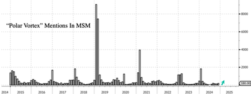
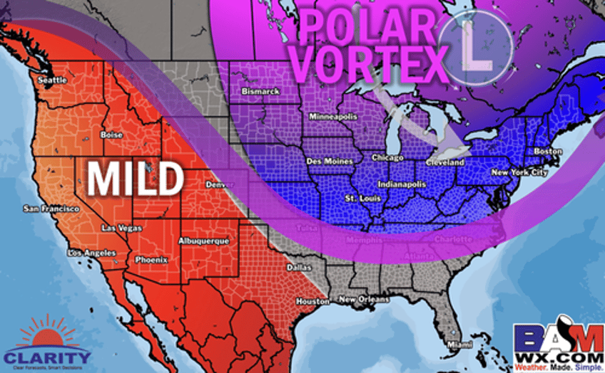
It's almost that time of year when a polar vortex split occurs, displacing cold Arctic air from the Earth's North Pole into Canada and spilling into the Lower 48.
Data from Bloomberg shows that mentions of "polar vortex" in corporate media typically begin to surge in late December or the first half of January, signaling that the countdown has begun.
On Wednesday, private weather forecaster BAMWX pushed out new weather models on X, showing confidence is growing for a polar vortex split to occur for the Lower 48.
"The stage is set for Arctic outbreaks to round out December and kick start the new year!" BAMWX wrote on X.
BAMWX said, "More favorable trends for stronger cold fronts in week 2. I don't see any signs of a consistent torch in the eastern US. Ensembles cannot resolve the +TNH & +PNA pattern right now making them consistently too warm late week 2."
More favorable trends for stronger cold fronts in week 2. I don't see any signs of a consistent torch in the eastern US.
— BAM Weather (BAMWX) (@bamwxcom) December 11, 2024
Ensembles cannot resolve the +TNH & +PNA pattern right now making them consistently too warm late week 2. pic.twitter.com/EuOcMnGFZ9
Michael Clark, chief meteorologist for BAMWX, was confident about the incoming polar vortex.
Yes. Really. https://t.co/fv95vY03ii pic.twitter.com/4F6h9SZKbe
— BAM Weather (BAMWX) (@bamwxcom) December 11, 2024
Clark also sees a more active precipitation pattern for the eastern half of the US.
I also strongly agree with the AI data that the pattern is much more active than what the week 2 ensembles show for precipitation.
— BAM Weather (BAMWX) (@bamwxcom) December 11, 2024
The 12Z EPS & GEFS has trended wetter in today's runs which we believe to also be the preferred route here. pic.twitter.com/cRik6dQteq
"The persistence in the PNA and the TPV (500mb tropospheric polar vortex location is the reason we believe the storms can easily pull down the Arctic air behind them," BAMWX said.
The persistence in the PNA and the TPV (500mb tropospheric polar vortex location is the reason we believe the storms can easily pull down the Arctic air behind them.
— BAM Weather (BAMWX) (@bamwxcom) December 11, 2024
It's likely the smoothed out ensemble means are missing these features.
Therefore the AI data as of today has… pic.twitter.com/CvCqhXae1G
The eastern half of the US appears to be setting up for a cold Christmas.
Morning data runs 12-20 to 12-25 aka leading up to #Christmas.
— BAM Weather (BAMWX) (@bamwxcom) December 11, 2024
Everything is colder east.
With that said the ECMWF-AI is quite a bit colder and we think that is because it understands that the TPV is not moving while the other data fails to see the connection. pic.twitter.com/YOCmVbDyrF
And possibly a white one...
The odds of 1"+ of snowfall between now and the 28th.
— BAM Weather (BAMWX) (@bamwxcom) December 12, 2024
I think we need to watch this area here for increasing odds of a white #Christmas. pic.twitter.com/RSFIl7G2yd
"Both GFS and ECMWF AI model data hinting at a bigger storm threat ~22nd of Dec," BAMWX wrote in a forecast.
Both GFS and ECMWF AI model data hinting at a bigger storm threat ~22nd of Dec.
— BAM Weather (BAMWX) (@bamwxcom) December 12, 2024
This storm has been on the charts for several days now.
There is absolutely a storm there we need to take a look into the odds of having an Arctic connection for a bigger Winter storm? pic.twitter.com/037pXkPlgu
Here's more from Clark in a video titled "Stage set for ARCTIC OUTBREAKS to start 2025" ...


